A Trip to the Desert On May 17-19th (Friday to Sunday), I made my first trip involving an overnight stay: one night in Death Valley, then two nights in Palm Springs. At least, that was the plan. Weather was forecast good for the weekend, but deteriorating on Monday. Clear weather was essential for the first leg, crossing the Sierra Nevada on the way to Death Valley. Friday |
|
 |
Advice for mountain flying always says to do it early in the morning or late in the day, when turbulence will be least. However we had commitments which meant we couldn't leave until mid-day, and we wanted to arrive no later than early evening. Weather was forecast clear, with radar and satellite confirmation. As usual, getting everything packed up and out of the house was a challenge. My original target of wheels-up at 1215 became 1330, then I filed for a 1415 departure, and we in fact took off at 1504. I filed a VFR flight plan since I figured that if we had to come down in the mountains it would be nice if someone came to look for us. |
 |
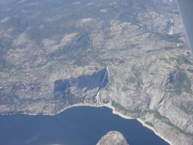
The planned route was straight across the Valley to Pine Mountain Lake, then up to Tuolomine Meadows and straight on to the south of Mono Lake, a route advised by my friend Bill. My instructor had suggested a southerly route cutting round to the south of the Sierra Nevada, but there are so many SUAs by this route that it isn't really practical. The northerly route via Tahoe involves lower peaks but is a 60 mile detour. This route involves crossing a ridge at about 11000', with peaks either side at 13000'. We crossed the Valley at 7500', then climbed to 11500' over the foothills. The views are spectacular, including a lake with a waterfall of several hundred feet which would be just about impossible to see any other way. |
 |
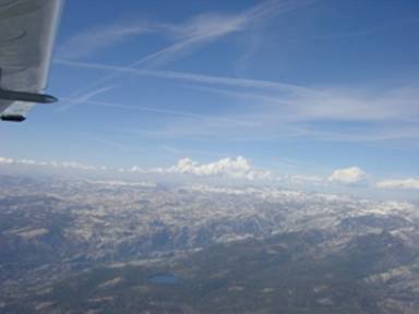
As we flew across the valley I could see a line of clouds which I guessed were over the ridge – as indeed they were. The bases were probably above our planned crossing altitude, but only just. Fortunately there were a couple of gaps, one of which turned out to be exactly where we wanted to go. The last part of the crossing was truly spectacular. I climbed to 13500', a test for both me and the plane since I had never flown this high before. Worries about hypoxia and about a miserable climb rate both turned out to be baseless. Our valiant little plane went all the way at 500 ft/minand 85 knots, despite a load including 5 gallons of water in case of a desert landing. As for hypoxia, we had such fun and we were so happy… no, seriously, it was a non-event. |
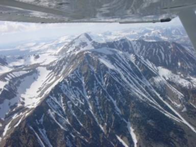 |
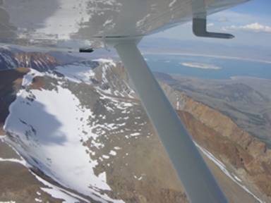
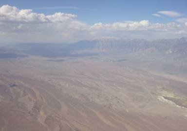
The ridge crossing was magnificent. Although we had 2000' under us, the ridge rises either side and you can almost reach out and touch the snow-covered peaks at 13000'. It is very impressive seeing the ground rise and rise towards you. Then suddenly the mountains fall away in what seems almost like a sheer drop, with Mono Lake magnificent on our left, and we were over the beginning of the desert country, turning south towards Mammoth and the beginning of my first desert flight. It's impossible to describe the desert without using cliches like "ever changing vistas". The absence of water and vegetation actually makes things more varied, since the geological structure is on constant display, with every stratum, fault-line and landslide clearly visible. I selected a fairly twisty course to avoid long flights over mountains, with the GPS a great help for this – Isabelle was a champion as she entered all of the tricky waypoints for this route. There was a fair bit of turbulence, which means that I hand flew a lot of the time – the autopilot does work in turbulence, but it seems to over-correct and it is more comfortable to hand fly. |
 |
We entered Death Valley itself from the north, starting our descent from 11500' immediately. I'd originally gone lower, but turbulence made it more comfortable higher up. As we gradually let down through the valley, the OAT went up alarmingly – at 6500' it was already in the high twenties. Isabelle managed to spot the elusive Stovepipe Wells "Airport" – a barely visible smudge in the desert, then we rounded an outcrop and started to look for our target, Furnace Creek (L06). This too was fairly hard to find, but eventually we did and overflew it looking for a windsock, which was not to be found. I ended up landing on 33 when in fact the winds were very distinctly the other way. I made a terrible landing, floating for ever and getting within a second or two of a go-around before dropping in with a very distinct protest from the gear. No damage was done and I stopped well before the end of the runway, whereupon I found the windsock and saw that it was sticking out in the opposite direction. No wonder the landing was terrible. |
 |
The temperature on the ground was a staggering 45C, which with the aforementioned strong wind made it like standing in front of a giant hairdryer. Isabelle called the Furnace Creek Inn, who quickly sent a bus over while we were tying the plane down. (No tie-downs, just steel wires along the ground, so I got to use my back-country tie-down kit). The guys from a P210 that landed just after us elected to walk to the hotel, to give their two boys an 1849 experience. We were drying off after a swim by the time they arrived. I'm glad I missed 1849. Our flight had taken 2h25 for 300 nm, against a planned 2h22. One more "oops" moment: at 1900, 90 minutes after arrival, I realised I had not closed the flight plan (despite a key tag with a "have you closed your flight plan" streamer). I called the FSS who fortunately had been able to get a Park Ranger to verify that the plane was there, so no serious harm was done except to my pride. |
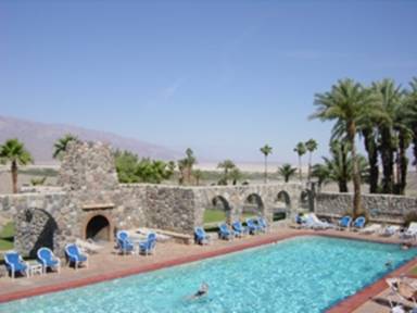
As for the Furnace Creek Inn, it is both literally and figuratively an oasis in the desert, with its own deep wells and water supply. It is just like a resort island in the tropics, except that there is desert instead of sea. At 11pm when we went to bed after a good dinner, it was still 100F and people were still swimming. I woke at 1.30am and had to sit in front the air conditioner for five minutes to cool off enough to go back to sleep. At 6am it was still in the eighties, so much for it getting cold at night in the desert. Saturday |
|
 |
A late start (nothing unusual there), as after waking up at 6am I eventually went back to sleep and didn't wake up for a second time until 9.30 or so. Then a leisurely and plentiful breakfast, from which Isabelle salvaged the makings of lunch as well. The planned route was more or less south across the desert, so not surprisingly weather was not expected to be a problem. I asked about all the MOAs I remembered, which were all cold, making the route more direct. After getting everything packed we went for a final swim in the hotel's olympic sized pool. Packing wet swimming things isn't a problem at Death Valley – just leaving them outside for five minutes is enough to dry them thoroughly. The temperature was already well over 100F by then. |
 |
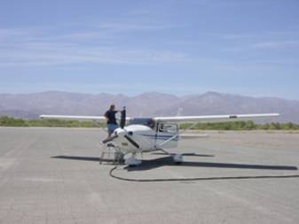
We took the hotel bus, first to the gas station to pay for gas, then on to the plane. By the time we had loaded, a guy showed up to pump the gas, a fairly civilized arrangement. Taking off from below sea level was no big deal, mainly because it was so hot that the density altitude was about 3000'. As we started to climb I realised that I had forgotten to ask about the Panamint MOA, which was unfortunate because we were already in it and so were the first 30 or so miles of our planned course. It is normally only in use Monday to Friday, but I thought I'd better check. I managed to raise an FSS, rather to my surprise, who told me that it was in fact hot. That meant keeping below 3000', so I held 2000' or so. This was pretty bumpy but did give us a magnificent view of the desrt, flying between the mountains on either side. It was however really hot – the OAT showed 36C and with the sun shining we were really sweating inside the cockpit. We flew over the lowest point in the US, at minus 282', then turned East as soon as possible to get over some hills and out of the hot (in all senses) MOA. We saw occasional airfields – very difficult to pick out since they are just more desert – another oasis at Teculpa, and then just more and more desert. This area was General Patton's training ground for desert warfare, and covers thousands of square miles. |
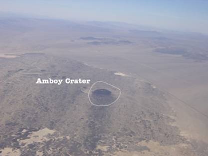 |
After 40 minutes or so we reached Amboy. This is a tiny town on the original Route 66, famous now for Roy's Diner. Roy has his very own landing strip, and it was tempting to drop in for lunch but I'm not really sure about landing N430P on a dirt strip so we passed the opportunity and relied on our sandwiches instead. You have to be careful round here because there is a huge restricted area. The Amboy Crater is just inside it but can be clearly seen without trespassing. There were traces of the desert training ground everywhere, as well as occasional gold mines, still active. Around here I made my first ever PIREP – I called to get weather at Chiriaco (answer: the nearest reporting station is 40 miles away), and thought it only fair to give them one, although there wasn't much to say except to report the light-to-moderate turbulence we had had all the way (more hand-flying). Eventually we reached I-15, with the runway at Chiriaco Summit (L77) in sight. The landing was a bit of a challenge because flying a left pattern into runway 06 means getting uncomfortably close to the mountains to the south. At least I managed to get correctly aligned with the wind this time although it was pretty much directly across the runway at 12 knots or so. |
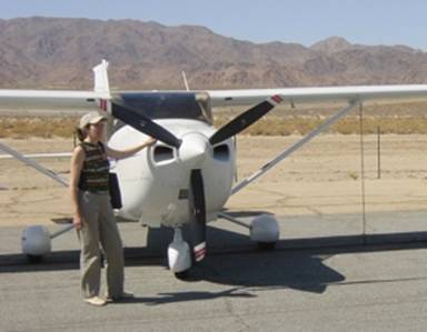
On the good side, radio technique is of little importance – I made all the usual calls but honestly I doubt that there was another airplane within 100 miles. I even remembered to close my flight plan in the air. The runway looks as though it has been painted on – this was originally the main airfield for Patton's Camp, and relatively recently (i.e. some time in the last 60 years) it has been resurfaced but only a small part of the original, which remains crumbling either side and at the eastern end. Taxiing off the runway lead to a small tie down area with one other plane and no signs of life, but a short walk from a truck-stop on I-15. The community of Chiriaco Summit consists of a gas station, a small supermarket and diner, the General Patton museum, and a trailer park with a dozen or so trailers for the people who work there. I guess it must be better not to hanker after the big city. |
|
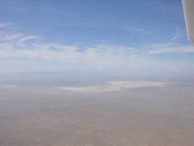
We walked through the truck stop to the reason for our stop, the General Patton museum. Considering it's in the middle of nowhere this is surprisingly well done, I guess it must get a fair amount of custom from people on I-15 – reminiscent of Bill Bryson's description of long cross-country drives as a child ("General Patton Museum – only 180 miles"). There was a long video about the camp and Patton's role during the war, and numerous artefacts suggesting that the main recreation of the inhabitants is searching the desert with metal detectors. Outside there is a collection of tanks, but honestly one down-at-heel tank looks very much like another and Isabelle was mostly interested in the plants. Then we walked back through the truck stop to our faithful airplane. Anybody who flies fuel-injected planes knows that the very worst thing you can do is fly for an hour or two, land, park for another hour or so, then try to restart the engine, because of vapour locks from the hot fuel in the injection pipework. Doing this in the desert is particularly ill-advised. I'm still working on the hot-start technique, so far without any spectacular failures (i.e. flat batteries). Everything was fine this time, using full-rich mixture and no prime. Then a quick run-up, back-taxi all the way down the runway since it is the only paved surface, and off again this time for Palm Springs. The desert cities and the Salton Sea were visible as soon as we started climbing. I was tempted to go and fly over the Salton Sea, which must be the world's biggest accidental lake, but we had already been flying for a long time and we were quite keen to arrive. (The story goes that they were building an irrigation aqueduct, and something went wrong. It took them two years to stop the leak – itself a record for turning a tap off – by which time the Salton Sea had been created. It is now slowly evaporating and in a few centuries it will have gone again). Palm Springs is very unusual in the US in being a TRSA, which is a kind of inferior Class C in which you don't have to talk to them if you don't want to. I don't really see the point, it would be one less thing to remember if they just made the handful of them Class C, but I suppose the people with vintage no-radio planes would object. Anyway, it's just as well, because flying at 5500' I couldn't reach anyone on the radio until I was well inside the TRSA. Maybe that's the reason – if they made it Class C they'd have to upgrade the radio equipment so that you could talk to them. Maybe it's my accent, but I have terrible trouble getting controllers to read back the right tail number. I've been N43ZP, N403P, N43SP, and goodness knows what else. (Having a short number does have its problems – on our way down LA Center was talking to N430PA as well as us). I try to correct them but sometimes it's easier just to remember who they think you are. Anyway this time it led to confusion, because there really was a N43SP or similar in the area, so I kept responding to the wrong calls until the controller got fed up and said "aircraft responding to calls to N43SP that is something else, standby – I'll get to you". Finally we landed on 13L – unsual because normally the wind blows in from the Banning Pass and you use 31L/R. As we were rolling out I realised that I had no idea which FBO to use. Tower was very helpful: "Use Million Air, they're on your side of the field". So I did – very fancy service, with a golf cart that came out to the plane to collect us, and a taxi waiting for us. This is really about flying, but I have to say something about our stay in Palm Springs. We went to the Ballantine Hotel, which is all 50s-retro styling. It took a while to find it, because actually there are two of them and we initially went to the wrong one. The pool was rather smaller than at Furnace Creek, with the rooms around it. We liked our room straight away, very simple but stylish and not at all pretentious. After a shower we decided to walk into town for dinner – at the Canyon Bistro, where it turned out we had eaten on our last trip to Palm Springs. We liked it just as much this time, and had a bottle of almost-champagne (Domaine Chandon) with a good fusion-style dinner. The walk was a bit of a stretch, a bit over a mile each way, and in fact the other half of the hotel is much closer so probably we'll go there next time. |
|
SundayWe weren't sure what to do with Sunday. The truth is that Palm Springs isn't very big, and if you've been there once you've seen it all. We thought about flying somewhere, maybe over the mountains to one of the San Diego area airports, but a look at ADDS showed that the whole coast was socked in. This got me pretty worried about the weather. A big storm system was moving in from the ocean, threatening clouds and rain for Monday and Tuesday, and although we liked the hotel we didn't really want to spend the week there. The TAFs for the Bay Area were beginning to look not-too-great even for Sunday, so we decided that we should leave today even though we had prepaid the hotel. We went for a swim and had a rather minimalist breakfast by the pool. The hotel is rather intimate, almost like being at someone's house, with everyone eating around the pool. Isabelle asked them about leaving early, and amazingly they offered to refund one night without even being asked – so we will certainly stay there again. A call to the FSS was not very promising – "VFR not recommended for the Bay Area". But he admitted that we would probably get to Stockton, so we figured we'd get as far as we could and work it out from there. We went for our second walk into town, to get some lunch and have a look around. We found an interesting furniture store, and a hotel right in the very centre that could be possible for a future stay. Then we had lunch at Ruby's Diner, which (like our hotel) is very 50's-retro but also served some decent food, and I had my once-a-decade milk shake, which seemed to fit very well with the ambiance. After that we walked back, which was probably a mistake since by then it was awful hot, and then off to our friends at Million Air again. It seemed to take us ages to get ready to depart, I'm not sure why. We were at the airport well before 3, but we were not wheels-up until 1531. During the whole of that time a Citation stood on the ramp with its engines running, presumably waiting for its super-important customer who did eventually show up just as were were taxiing onto the runway. The obvious route back is through Banning Pass, then northward through the San Bernadino mountains towards Edwards. However the whole LA Basin looked terrible, so I decided to go straight north and then turn west towards Victorville. As soon as we left the runway (13R this time) we hit really bad turbulence, which got worse and worse as we climbed until eventually we were all over the place with the Skylane's super-sensitive stall horn beeping constantly. Approach promised us that it got better at 6000', but it seemed to take an awfully long time to get there. They were right, though, because at about 5800' everything magically got smoother, and after that we had a smooth ride nearly all the way back. |
|
 |
There followed an uneventful ride across the desert at 10500' (the minimum altitude for flight following in the area). We overflew Victorville, with an impressive collection of airliners out to pasture, and then Palmdale, with a distant view of Edwards. From our altitude we could see that the LA Basin was indeed socked in, although I think we would just about have made it via Banning but everything west of there was covered with low cloud. I'd planned to take the Tejon Pass into the Valley, but there were clouds over the ridge and I ended up crossing midway between Tejon and Tehachapi, dropping to 8500' to miss the clouds. |
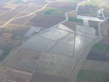 |
After that came the long slog up the valley, with I-5 to our left and initially Bakersfield to our right with its multiplicity of airports. Bakersfield approach handed us off to Lemoore, which had me puzzled because I'd never heard of them and thought they said Livermore. It's awkward when you get a handoff and you don't recognize the name. You have the frequency so you can reach them, but how do you make the first call? I'd decided on "mlbmmm approach, Skylane 430P with you at 8500", when Isabelle found Lemoore on the roadmap. Then I decided to call Flight Watch and see how things were shaping up in the Bay Area, but this proved to be an exercise in frustration. I could hear everything that was going on, but could never get a response to my calls. I went back to Lemoore and tried again later – this time it was rather an exercise in irritation. Eventually I got an answer from a rather broken-up controller who said, "Airplane calling, are you calling Oakland?" How would I know? – I just called 122.0 and there in the middle of the Valley I haven't a clue who is going to answer, nor any obvious means to find out. So I said I didn't know and got the answer, "If you don't tell us who you're calling, how do you expect us to answer?" He may have had a point, but we seemed to be at an impasse, and anyway it cost him a PIREP – not that there was a great deal to report. By this time we had scattered to broken clouds above us and had already dropped to 6500', and passed through a big area of haze with fairly poor visibility. Weather in the Bay Area sounded OK, so we were pretty optimistic about arriving at Palo Alto. Somewhere around here we passed close to the eponymous San Joaquin and its neighbour Tranquility – which indeed looked a pretty quiet sort of place. Although the Valley is flat, the textures of the landscape are constantly changing and in some places are quite beautiful. |
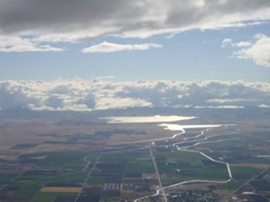 |
By now we were getting closer to home. We passed Los Banos on our left; I picked out the airport, though not the famous experimental McDonalds which I'm told is next to it. We had a beautiful view of the Los Banos reservoir with the sunlight reflecting silver off of it. From here we could see the cloud in the Salinas Valley, which did not look at all friendly. I was very glad that we had not chosen that as a route home. From here I could see the hills right up to Tracy, so things were definitely looking good. I had to descend some more, first to 4500' and then down to 2500' to get under some cumulus, with lots of bumps underneath. Finally, with Tracy in sight, I could see clear over the Altamont pass, and as we got closer I saw the light reflected off the Bay itself. Now I knew we could get there, and not spend the night in a motel in Fresno or Los Banos. A straight run south of Livermore, a little aggro from Bay who terminated flight following without telling us, so that when I called to report Palo Alto in sight they said "You were terminated five miles ago. Squawk VFR and don't come back this way". Well, they didn't actually say the last bit, but I'm sure they thought it. They had me on a weird frequency anyway. |
Palo Alto was busy as ever, despite the
weather which was overcast at 4000' or so and not very friendly. They had us do a 360 on
the way in then some more fancy footwork to get behind our traffic. Then,
finally, onto a soggy but sunny runway 13 exactly 3h05 and 390 nm after departure, with a
fair crosswind directly across the runway. As we were cleaning up, I talked with
someone else who was just in from LA, who had tried the Salinas Valley. He told tales of spiralling down through holes in the clouds, and VFR into IMC –
it made me very glad I had chosen the Valley route. And Isabelle reminded me to call and
close my flight plan – she is turning into a really good co-pilot. |
|